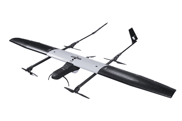
Switch UAV
All Terrain Dominator
Previous
Next
Overview
SWITCH UAV is a first of its kind VTOL and fixed wing hybrid Unmanned Aerial Vehicle. SWITCH features advanced flight time, higher safety and simple operation with additional fail-safe redundancies.
It is used for long duration operations, long endurance surveillance and security, inspection and photogrammetry.
It is used for long duration operations, long endurance surveillance and security, inspection and photogrammetry.
Features of Switch UAV
Lorem IpsumTechnical Specifications
- Endurance : >120 minutes
- Range (LoS) : 15 km
- Weight : <6.5 kg
- Wind Resistance : Up to 10.8 knots or 20 km/h
- Vehicle Size : ~ 2.6 m x 1.8 m
- Ingress Protection : IP53 Rated for Dust & Water Resistance
- Max Launch Altitude : 4000 m AMSL
- Max Operating Altitude : 1000 m AGL
Payloads
- Combined Day & Night Payload
- Daylight Payload : 1280 x 720 pixels, 25x Optical Zoom
- Thermal Payload : 640 x 480 pixels
Switch UAV Applications
- Anti Terror : Detect threats and identify risk-prone areas from a remote location
- Border Security : Conduct reconnaissance missions and track illegal activities without risking lives
- Counter Insurgency : Conduct surveillance and gather actionable intelligence
- Crime Control : Enhance law enforcement with remote situation assessment and crime scene analysis
- Crowd Monitoring : Detect irregular activity and gain in-depth situational awareness
- Disaster Management : Gain real-time knowledge of the situation and plan search and rescue operations effectively
- Forest & Wildllife : Track criminal activity and boost conservation efforts
- Traffic Monitoring : Analyze and control traffic movement and respond to emergencies more effectively
- Precision Agriculture : Analyze crop growth pattern and inspect crops for diseases quickly
- Construction & Real Estate : Inspect buildings, bridges, rail lines and other infrastructure without scaffolding or booms
- Industrial Asset Inspection : xamine solar farms and detect anomalies with fewer or no personnel
- Mining : Use aerial surveys and photogrammetry to improve blast optimization